Saturday, August 19, 2017

Lake Cowichan, BC, Sunny, 23

The Cowichan River Trail

 Once again, retirement strikes and we're off camping and hiking. This time with our long time friends Ted and Sue who we camped with often over the years as we raised our families. Always a very satisfying experience with good memories. While we are now all slightly on the other side of 60, we still enjoy our time together and as the relationship has matured the camping seems to get better...like a good wine aging. We have in the past taken the troops out to walk, but today (happily or sadly?) it's just the four of us. These days the walks are quieter, but just as fun AND, no bribes are required to keep the herd moving! The suggestion of a cold beer at the end of the walk usually suffices to motivate the four of us. Mind you, we're an easily motivated crew!
We walked yesterday, but most of it was road walking and fairly routine. I have no photo history, so you can imagine that the scenery was lacking, though the company and conversations were excellent. Today was another story. Ted and Sue suggested a walk along the Cowichan River, world renown for its Steele Head salmon fishing. Serious anglers equipped with fly rods and all manner of support gear make the trek here each year to see if they can land these highly sought after fish. Aside from the fishing, the setting is quite spectacular. 

We sourced the trail and off we went along the north side of the river heading down stream. 

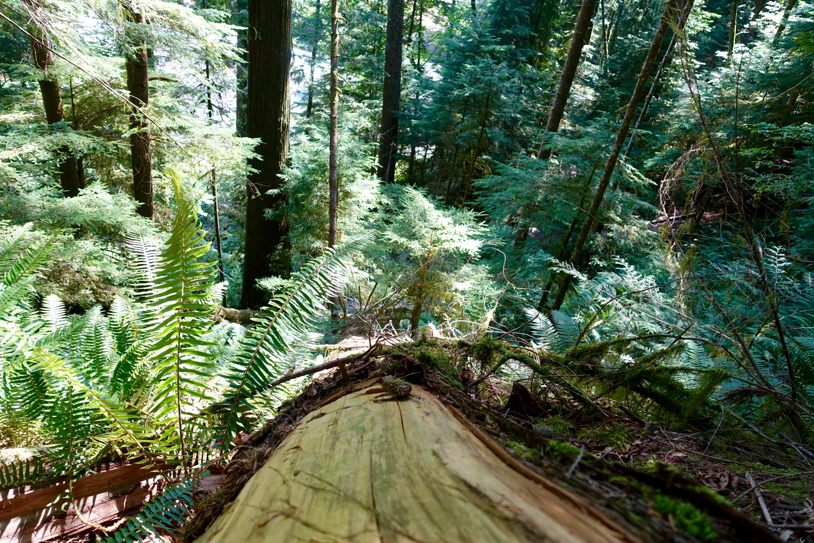
The trees quickly revealed themselves and it became quite apparent that we were walking through a moderately high precipitation belt. It's been extremely dry these past two months, but the fall and winter here experience decent amounts of rain. I really liked the trees and took far too many pictures as I usually do, but who really cares:)


We found ourselves pleasantly surprised as we followed the shore. My friend Dennis has since explained to me that the water rights to Lake Cowichan are held by the large pulp operation close to the river mouth. So a certain amount of water is released through the weir to satisfy the needs of the mill, which has a large diversion pipe to transfer water from the river. Over the years the water level of the lake has been maintained to assist with logging operations and booming, but those days are now long gone. Today water levels in the river are managed to ensure adequate flow is maintained for various residential downstream users, fisheries and recreational purposes.


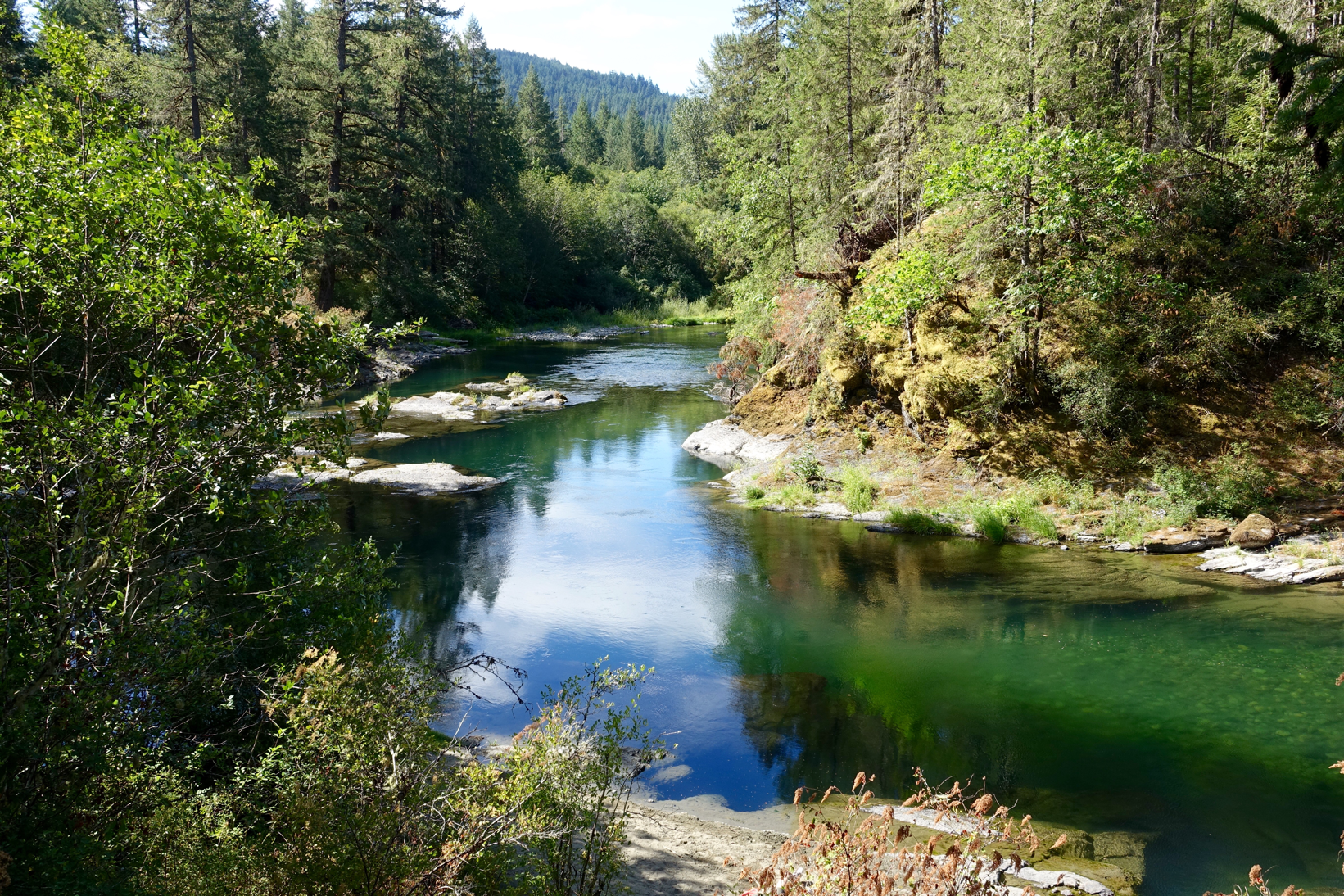
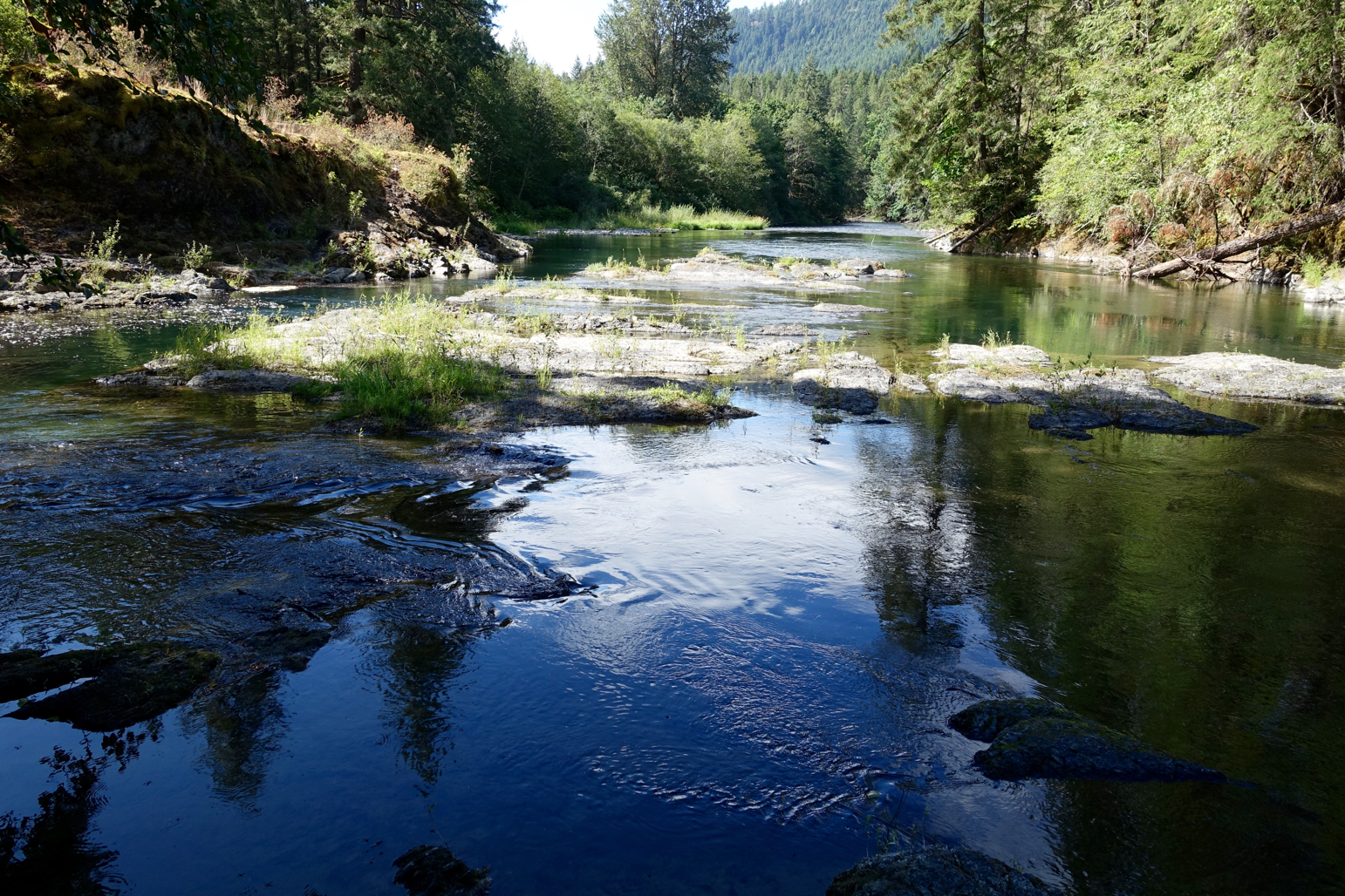
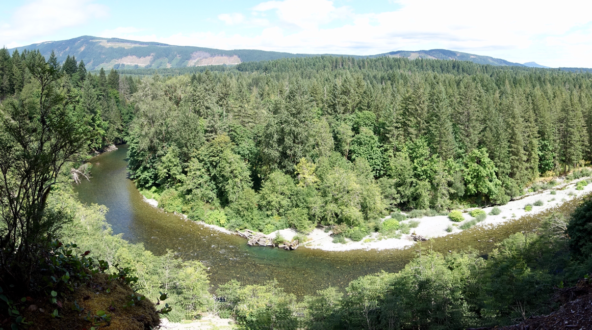
We eventually climbed up onto the cliff edges of the river canyon where the river had cut deep channels with the falling gradient. Essentially forming a beautiful tree lined gorge.


We continued to follow the river downstream, but eventually crossed a bridge and headed back upstream. I guess if it was raining hard one could take shelter inside here...better than getting soaked!


We eventually climbed back out of the gorge and again had access to the river.


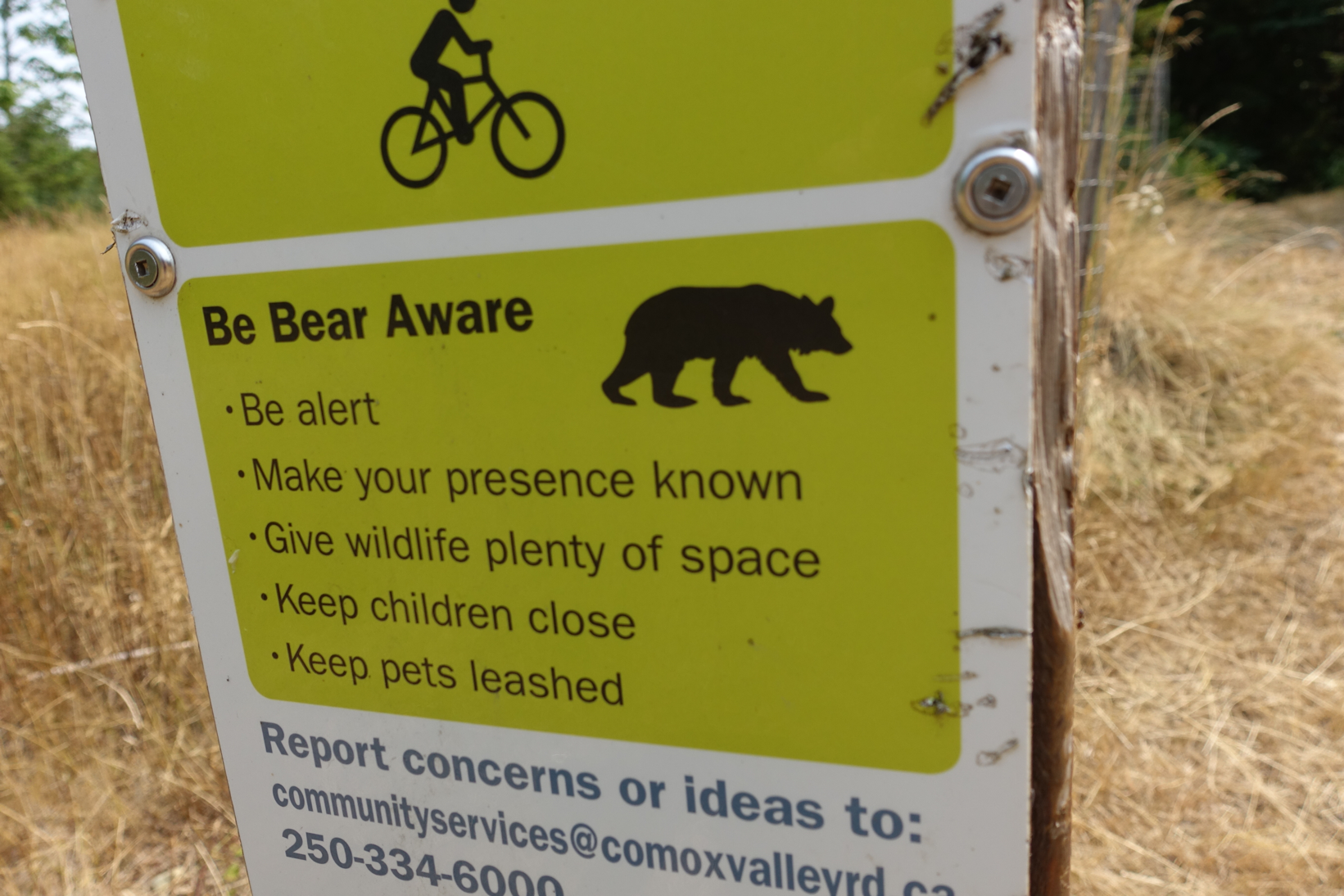
At one point we walked a short portion of the 22,000 km long Trans Canada Trail.  Some Camino that would be!!  Ken, Neil...what do you think??


High on cliffs above,
The river runs far below,
A day shared. Priceless.


Sunday, August 13, 2017

Bear Creek, Vancouver Island, Hike 3, Hot, 28

So, Where's Dem Bears?


We moved from the interior of the Island down to the east coast to camp and hike for a couple more days. A friend of Annemarie's, Michelle, kindly offered to talk us for a couple of walks to see a little of her area and we gladly accepted. Michelle was accompanied by her 1 year old Border Collie, Charlie, a lovely dog who was quite difficult to ignore!
The first walk was down to the mouth of Oyster River where I had completed some hydrology work to assist with Salmon enhancement studies in the early 1980's. Its a nice tidal estuary...for a dog to enjoy!
There was an odd sighting on the River, but that was about it.
We eventually headed northward along the coast line. It was pleasant, but fairly unremarkable, except for the smoke which robbed us of views of the stunning Coastal Mountain range. Such is life.

Then we moved more inland to walk along Bear Creek, another part of the Salmon Enhancement study where considerable time and effort has been expended to improve the salmon runs. It was a good walk and while we saw no bears, there was definitely bear signs as the sign posts confirmed! So yes Neil, there are bears in this area, I've encountered them here before.


The tributaries have been 'managed' to encourage spawning activity and they have done an excellent job.


There are also quiet areas where the fry are protected from the local wildlife for the first year before they are released into the main stream to head into the open ocean.

We found a pub for a nice lunch and after saying farewell to Michelle and Charlie we headed back to camp and watched the ebb and flow of the smoke and enjoyed the sunset.


Once home the smoke became more intense and settled in for over 10 days, but happily last night we had the first short rain in 2 months and the accompanying wind shift has sent the smoke back again into the eastern interior. A very pleasant change!!

Wednesday, August 9, 2017

Strathcona Park, Vancouver Island, Day 2, Hot, 31

'Smokin Hot'

An apparent shortage of fuel for our vehicle 'drove' us to head back towards the west coast where we decided to walk the Centennial Trail and the Elk Falls Trail, conveniently connected to each other. At 17 kms not a particularly long walk, but there were a few ups and downs along the way to add a bit of variety. It was a very hot 31 degree day and with outflow winds predicted to push the heavy smoke from the interior BC fires in our direction we figured it was best to not push ourselves to hike to any meaningful elevations today. The walk we selected was often in the shade of the forest, so manageable given the circumstances. The Parks folks claimed there were some sections of 'old growth' forests, but I think the area was previously logged at some point, though the trees were very impressive. 

The Elk Falls were stunning with a steep drop off a cliff after the upper falls and narrow channel.

I really enjoyed the way the light played on the maple leaves that found their way into the forest canopy. Stunning greens that reminded me of the same scenes in Japan as I walked into Spring. I never really noticed how the colours can stay vibrant well into the hot season. Or perhaps it was just the play of light?
We walked further  up towards the lake outlet and found a couple of beautiful falls which I did my best to capture with the use of a log to stabilize my camera.


On the return leg we came from the upstream side of Elk Falls and we enjoyed the surge of water as it pushed past our rocky position. I was able to walk fairly close to the edge to capture the last moments before the water disappeared.


We wandered on down the trail and found some pretty cool views. 

I thought it was a surprisingly long way back up to the suspension bridge. I know this wouldn't bother my pal Neil, but I would be a little challenged by this.

We completed the Elk Falls circuit and continued on to the Centennial Trail. The smoke from the interior BC fires began to arrive about this time and it was immediately noticeable. The CT began a steady decent through a beautiful forest.


Another high bridge to cross...steady myself, prepare and then cross!
Down a long series of stairs...2017, without doubt, The Year of the Stairs. I'm still sick of stairs!!
We arrive at a beautiful trail which follows Campbell River downstream for several kilometres. Lots of fisher person types.
We cross the river and hike back upstream and across the dam thinking that its been a pretty good day. We met a few interesting folks along the way and found another series of good walking trails for future reference. More places to take friends when they visit our country.

On the way back up to Strathcona Park I stopped to take a look down Buttle Lake, just as I had that morning. The morning photo...
The afternoon photo...

Since then, it's of course become much worse. At home we didn't have a sunset for about four days. This was the first one, and with my binoculars I could see the sun spots. 

We finished our day with a dip in the lake. Somehow it seemed like the lake was warmer than it was the day before. Is that possible?


Friday, August 4, 2017

Strathcona Park, Vancouver Island, Sunny, Hot, 28-31

Walking The Falls
(Home again, I wrote a series of posts off line while away this past week and I'll clean them up and post with photos over the next few days)
Day 1

We've taken off for a week of camping and hiking. Some time to get away from our home based lifestyle and a chance to commune a little with nature. By chance we selected the hottest week so far this summer, but our tent is set up in the trees and I sit here sipping on a very tall, cold beer! Not too bad at all:)  The goal this week is to suss out new hiking areas and taste bits and pieces as we build a data base of places to disappear to in the mid and northern parts of Vancouver Island. It will be nice to find some new hiking areas closer to home that don't always require an airplane to travel to.
Having been home from Japan for two months and well along in my chore catch-up program I'm beginning to get itchy feet again. I've headed off to walk various Caminos in Europe three of the last four summer/fall seasons, so naturally my body and mind are telling me that it's time to get ready...time to walk. I tell both body and mind that we've already had our long wander for this year, but body and mind in turn tell me that this isn't really a very satisfying response. Nope, not satisfying at all. I've walked a couple of good long walks at home the past week, but they only served to confirm that I 'could' head for Europe on a moments notice to begin again. Not likely the best idea, though I'll admit in a moment of desperation or two I've quietly approached Annemarie with a few 'suggestions':) 

Fortunately we have lots of excellent hiking on our huge island so we have travelled north to seek out a few new vistas and to see what we can find. If today was any indicator, then we've at least managed to satisfy our need to see new landscapes and discover new places. Last night we walked up to a small lake above the campsite and found that we had it all to ourselves. Oddly, not a sign of bears. No scat, paw prints, broken branches...nothing. No point in bringing Neil here!
We returned to camp where we enjoyed dinner and a quiet evening without a camp fire given the province wide ban with BC experiencing one of the most severe fire seasons on record. Firefighters arriving from Australia, Mexico, Europe, America and parts of Europe. Thanks all for your efforts. Thankfully nothing significant on Vancouver Island, thus far. Still two months left in the fire season.

Early this morning we drove south along Buttle Lake checking out the area before deciding where to hike. All very nice. Reminded me so much of parts of the Bowron Lakes. The canoe would have been brilliant to have here. Another time.
Eventually we began to wander on some of the hiking trails, the first one taking us through a beautiful cedar, hemlock and Douglas fir forest to some very nice water falls, Lapin Falls. Pretty nice we thought. A surprising amount of water coming down given that there hasn't been any rain the past 6 weeks. Of course there is still late snow up high, which will feed the streams and springs for quite some time.
We headed further south along the lake...
...and came to the Lower Myra Falls where we hiked in and were delighted by what we found!
 Further upstream through a lovely forested area we found the upper falls.
At the far south of the lake we decided to return tomorrow to hike up into the alpine along the Upper Myra Falls trail and possibly the Bedwell Lake route. 

On the way back I suggested that we drive westward to Gold River and find some lunch. Excellent decision as we found the best BLT at a small cafe and enjoyed a nice break as it was heating up. Our 2 minute tour of Gold River revealed that we had indeed seen Gold River to the fullest extent possible, so we decided to head back and see what else might be available to walk. We stopped to walk into an elk feeding range, but no luck. It was probably too hot and the females with their calves had clearly left the open ranges to seek the comparative coolness of the forest. The big males would be up higher in the alpine at this time of year.
We pressed on and discovered another hike up to Lady Falls through tall stands of 250+ years old Douglas fir trees.
Surprisingly, still a high volume flow coming down from up high here as well.
These falls are really quite high. I was standing on the edge of a cliff and believe me, it was very high!!

So a decent first day of walking. No massive distances covered on foot, but plenty of beautiful scenery and some lovely vistas. The lake reminded me of the 180 km Bowron Lakes canoe circuit in north central BC. I first paddled this stunning chain in 1971 and paddled it the fourth time with our son Bryan in 2012 and I've found it to be quite magical each time. I'm already beginning to think about the possibilities. Perhaps in late August next year. Take our time and complete the chain in 9-10 days. In past I've usually had to complete it in a week, but with our present life style this is no longer the case. Late season would mean fewer mosquitoes and nasty flies. Perhaps Caitlin and Paul might like to join us? Something to think about.

Here are a few photos from that 2012 trip. The wheels were allowed for the first time to help with portages. Pure luxury!


 Loads of moose, beavers and bears. Loones too.